You have 0 items in your cart

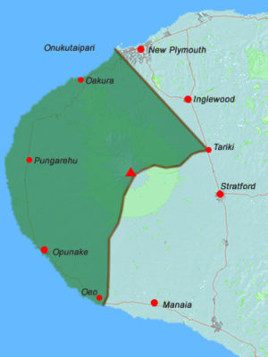
The rohe map represents the area over which Taranaki Iwi exercises kaitiakitanga for the purposes of the Resource Management Act 1991 and is based on the Area of Interest agreed between Taranaki iwi and the Crown in the Deed of Settlement signed on 05 September 2015. Taranaki iwi Area of Interest from the Deed of Settlement [JPG, 419KB].
The rohe of Taranaki Iwi extends into the regions or districts of the following local authorities:
Regional Council
Taranaki Regional Council
Territorial Authority
New Plymouth District Council
South Taranaki District Council
